Elizabeth Mazzoni1, Andrea Coronato2, 3, Jorge Rabassa2, 3
1 Universidad de la Patagonia Austral, Unidad Académica Río Gallegos. Lisandro de la Torre 1070, 9400 Río Gallegos, Argentina.
2 CONICET-CADIC, Bernardo Houssay 200, 9410 Ushuaia, Argentina.
3 Universidad Nacional de la Patagonia San Juan Bosco, Sede Ushuaia. Darwin y Canga, 9410 Ushuaia, Argentina.
Introduction
The Patagonian Region occupies the southern end of the South American continent, extending between latitudes 37° and 56° S. Along its western portion the Andean Cordillera is located, being the result of the Cenozoic orogenic processes and an intense plutonic and volcanic activity. This section of the Cordillera is known as the “Cordillera Patagónica” or Patagonian Andes. The “Cordillera Principal”, where the Aconcagua Mountain (6,800 m a.s.l) is located, is found northwards, in central Argentina and northernmost Patagonia. This mountain range is the backbone of South America, being the most important positive relief element on the continental scale.
The Southern Patagonian Andes (Ramos, 1999) extend from the latitude of Lago Fontana (44º 58´ S) until the Seno Otway (53º 55´ S) in the Magellan Straits region. At latitude 46º 30´ S it is divided in two segments whose structure, geological composition, topography and geological history are significantly different. This boundary is coincident with the Aysén Triple Junction, which in the Pacific Ocean sector separates the Nazca and the Antarctic plates (Ramos, 1989). The northern area, though it exposes a volcanic arc, has a lower relative relief than the southern sector. The latter is described below in greater detail due to the large variability of its geomorphological features, typical of high mountain environments modeled by past and present glacial processes.
Geology
The southern portion of the Southern Patagonian Andes (Figure 1) is composed of a fold-and-thrust belt, generated by the collision of the Pacific tectonic plates, which developed shortening and uplifting of the mountain ranges (Ramos, 1989). It includes many granitic peaks such as San Valentín, San Lorenzo, the famous Fitz Roy or Chaltén, Murallón, Stockes and the spectacular Torres del Paine, whose elevations range between 2,000 and 3,400 m above present sea level. All these features have impressive, almost vertical side slopes modelled by glacial erosion, of great interest to expert climbers and mountaineers.
This portion of the Cordillera has a few, small volcanic cones, which are found south of lat. 48º S along the Andean Volcanic Zone (AVZ; Stern, 2007), coinciding with the segment of the Antarctic oceanic plate which is subducting underneath the South American continental platform. In the AVZ only six small stratovolcanoes are found, largely separated from each other, located in the westernmost portion of the Cordillera. Some of them, as the Lautaro and Viedma volcanoes, occur amidst the Patagonian Ice Cap. Volcán Lautaro is the most active, with historical records that widely report about its activity (Martinic, 1988). Other volcanoes, such as Aguilera, Reclus and Mount Burney have had eruptions during Late Glacial and Holocene times (Stern, 2007).
Climate and vegetation
The regional climatic conditions show strong gradients in both W-E and N-S directions and in altitude, allowing to distinguish different climate types. The W-E gradient is determined by the action of the South Pacific Anticyclone, which sends winds that discharge most of their moisture on the western side of the Patagonian Andes. Thus, total rainfall reaches 4000 mm per year along the Pacific Ocean coast (hyperoceanic and oceanic climates) and then grades to values between 1200-730 mm per year at the western side of the Andes (meteorological stations of Coyhaique, lat. 45.6º S – long. 72.1º W, 310 m a.s.l. and Cochrane, lat. 47.23º S – long. 72.55º W, 182 m a.s.l., respectively; Servicio Meteorológico de Chile, http://www.meteochile.cl/climas/climas_undecima_region.html). Along the eastern slope and piedmont area, precipitation varies between 400 and 200 mm per year, approximately, defining sub-humid to semiarid climate types. At the El Calafate meteorological station (lat. 50.4º S – long. 72º W; 204 m a.s.l.; Estación Meteorológica El Calafate, Servicio Meteorológico Argentino) only 123 mm annual rainfall were recorded along the 1981-1990 decade.
The N – S gradient is related to the latitudinal extent and generates a progressive temperature lowering in that direction. The topographic effect is also shown in the thermal gradient. Starting at 800 m a.s.l., temperatures are low enough so as to maintain ice fields. There are no reliable meteorological records in this sector, but it may be estimated that the mean annual temperature may be slighlty below 0 ºC. The mean maximum temperatures raise above 0 ºC only in summer times, whereas the mean minimum temperatures are likely to be below 0 ºC all year around and extremely low in winter, thus generating snowfall almost exclusively (www.meteochile.cl). Under these conditions, there are no permanent human settlements in this area.
This climatic gradient has a great influence on the geomorphological and ecological processes, which exhibits contrasting landscapes as the observer moves from west to east. In this sense, and along approximately 50 km, the environment changes from very humid to semiarid climates and from rugged mountain landscapes to horizontal or subhorizontal surfaces, accompanied by ecosystems ranging from evergreen forests composed mainly of Nothofagus betuloides (“guindo”) in the western portion, to mesophyllic forests, formed basically by deciduous tress such as Nothofagus pumilio (“lenga”) and Nothofagus antarctica (“ñire”). Forests occupy mainly the mountain slopes whereas natural pastures fill the bottom of the valleys. Towards the eastern margin of the Southern Patagonian Andes, grassy and xeric steppes are found in contact with the forest (Roig, 1998).
Above the upper tree limit, approximately located at 1,500 m a.s.l., high altitude tundra is developed, with different types such as Magellanic tundra, Andean tundra, high altitude prairies with cushion plants and stony surfaces, showing sparse vegetation (Roig, 1998; Figure 2).
Glaciers and running water
Snow precipitation feeds the accumulation zones of the mountain ice sheet and other glaciers, known as a whole as the Northern and Southern Patagonian Icefield (“Hielo Patagónico Norte” and “Hielo Patagónico Sur”, NPI and SPI, respectively). These ice fields, which together cover up to 17,200 km2 (Skvarca, 2002), are the most important of South America and form a very significant fresh water reserve for Southern Patagonia. Discharge outlet glaciers descend from the ice fields along both eastern and western slopes (see Table 1; Figures 3 and 4).
The SPI is the more extended icefield, being the largest mass of ice in the Southern Hemisphere outside of Antarctica (Aniya et al., 1996). It has a mean width of 35 km and a minimum width of 9 km, and it is composed of 48 major outlet glaciers and over 100 small cirque and valley glaciers (Casassa et al., 2002). Those glaciers on the western slope end in deep fjords, whereas those in the eastern slope do so into relict glacial lakes located in ecotone areas. The largest glacier is the Pio XI Glacier, on the western slope, followed by the Viedma and Uppsala glaciers, which flow towards the eastern Andean slope.
In the Glaciares National Park of Argentina, close to the town of El Calafate, the Perito Moreno Glacier is noteworthy as one of the most accesible glacier tongues in temperate regions of the world, very well known for its peculiar glaciological dynamics, characterized by repeated advance of its front and subsequent damming of the southernmost branch of Lago Argentino, known as Brazo Rico. This glacier has a length of 30 km and an ice surface of 258 km2, distributed from an elevation of 2950 m a.s.l. to its terminal front into the aforementioned lake at an elevation of only 175 m a.s.l.
The glacier has not shown significative thickness changes in recent decades (Rignot et al., 2003) estimating that its mass balance is in equilibrium (Rott et al., 1998) due to, among other factors, the fact that its hypsometric distribution presents a strong slope in the zone around its equilibrium line altitude (ELA). Thus the temperature increase that took place in Patagonia between 1960 and 1990 (Rosemblüth et al., 1997) has not forced a significative reduction of its accumulation zone (Naruse et al., 1995). This glacier presents one of the highest net annual accumulation rates in the planet (5250 ± 474 kg m-2) and a very high rate of ice loss due to calving (that is, iceberg formation), what also explains the ice front stability of recent decades (Stuefer, 1999).
Table 1 shows main characteristics of the outlet glaciers of the Patagonian Ice Cap.
The lakes of this region are amongst the largest fresh water bodies of the South American continent, among which the Buenos Aires, Viedma and Argentino lakes are the most relevant, each of them with surfaces above 1,000 km2. See Table 2 for lake characteristics.
The drainage system is well integrated and it includes the upper reaches of allochtonous streams that drain towards the Atlantic Ocean and smaller basins which cross the Andean ranges towards the Pacific Ocean.
Landforms and modelling processes
The mountain ranges that form the Southern Patagonian Andes have, in general, very abrupt slopes and summits, with cirque glaciers and glacial troughs mostly occupied by lake basins (Figure 4). The relative local relief is very significant, sometimes over 2,000 – 2,500 m. The bottom of the larger glacial valleys is located around 200 m a.s.l.
These valleys are bounded by basaltic tablelands, complex moraine systems and glaciofluvial plains that were originated during the Last Glacial Maximum (LGM), which took place around 25 cal ka (Singer et al., 2004; Kaplan et al., 2004; Rabassa, 2008) or during Early and Middle Pleistocene glaciations (Rabassa et al., 2005; Rabassa, 2008).
This orographic system, modelled by past and present glacial action, covered by dense, pristine forests and drained by mountains creeks and lacustrine basins, offers a magnificent landscape of noted beauty and rich biodiversity which is protected by the “Los Glaciares” and “Perito Moreno” national parks in Argentina and the “Bernardo O´Higgins” and “Torres del Paine” national parks in Chile, several of them having been chosen as UNESCO World Heritage monuments (see Figure 1 for location).
The geomorphic processes that have modeled these landscapes are varied and complex, including endogenous and exogenous agents, which relative participation varies according to the analyzed geographical areas. The orogenic and volcanic processes had their maximum expression during earlier periods of the Cenozoic, but these processes are still very active, associated to the subduction of the Pacific oceanic plates such as the Nazca and the Antarctic plates underneath the South American continent. The intense eruption of Volcán Hudson (45º 55’ S; 72º 58’ W) in 1991 covered thousands of square kilometers in the Province of Santa Cruz (Argentina), in the southern end of the continent, with volcanic ashes that reached up to Tierra del Fuego. As a noted testimony of the present volcanic activity, while a first draft of this chapter was being completed, Volcán Chaitén (43º 30’ S) was erupting in Chile, throwing its ashes on to the Argentinean city of Esquel, located 100 km eastwards, to the entire piedmont area of the Northern Patagonian Andes in Argentina and even to the Atlantic coast of Buenos Aires province (38º S).
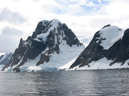
The cryogenic and glacial processes are still active above tree limit, at the summits and upper slopes (Figure 5). The glacier action is evident along the lowlands in which the large lakes of the oriental piedmont area are located, but also down to present sea level at the western margin, where an intricate network of glacial troughs, fjords and channels were excavated by the Pleistocene glaciers during the LGM, when sea level was at least 120 m below present sea level. The mass movement processes modeled the slopes with the genesis of stony surfaces in the higher zones of bare rocks, whereas landslides affected the forested slopes during periods of exceptionally high precipitation. Debris flows are concentrated in channels and ephemeral stream beds, transporting large glacial boulders and tree trunks, which usually generate drainage obstruction or diversion, and blocking roads in the piedmont or lowland areas.
Fluvial action appears to be dominant at present, basically due to high erosive power of mountain streams. The high availability of water in the system, provided by ice and snow melt and the abundant orographic precipitation, is shown by a very high drainage density of fluvial networks composed of permanent and ephemeral streams. The trunk streams reach the lower portions of the landscape where they flow in the main, flat-bottom, ancient glacial valleys with braided channel patterns. In these conditions, streams loose energy and increase alluvial deposition.
At the eastern piedmont of the Andes, where the large relict glacial lakes are found, coastal processes have modeled their shores by intense wave action, forced by the permanent action of the westerlies. In these open spaces, parabolic and longitudinal dunes are found, as well as erosive aeolian pavements, mostly following the ancient coastal lines lacking vegetation or related to deforested areas or with vegetation degraded by desertification processes (Figure 6).
Final remarks
The Southern Patagonian Andes is one of the regions with higher landscape diversity of the austral end of the South American continent. This geomorphological diversity, due to the regional geological and climate characteristics, offers a variety of natural resources, particularly those of scenic nature which have determined that a large portion of these territories is protected as national parks and natural reserves, including the declaration of the Glaciares National Park, among others, as UNESCO Mankind Heritage in 1981.
This mountain environment has wet and cold climate conditions that allow the development of a dense forest cover on its slopes and the survival of one of the most important ice fields of the temperate regions on Earth. The availability of water resources is also exposed in a very dense drainage network composed of many streams and large lakes of glacial origin. The rugged relief and the abundance of ice and water have favoured the development of active geomorphological processes that are accompanied by very strong wind action, particularly in the eastern piedmont.
Some of the most beautiful and spectacular landscapes in the Southern Hemisphere are found in the Southern Patagonian Andes. The combination of lively Cenozoic tectonics, powerful volcanic activity, vigorous glacial action, abundant meltwater runoff, harsh climate and pristine ecosystems has provided the suitable geomorphological scenario for the development of such a magnificent landscape.
Bibliography
Aniya, M., Sato, H., Naruse, R., Skvarca, P., Cassasa, G., 1996. The use of satellite and airborne imagery to inventory outlet glaciers of the Southern Patagonian Icefield, South America. Photogrammetric Engineering and Remote Sensing, 62, 1361-1369.
Casassa, G., Rivera, A., Aniya, M., Naruse, R., 2002. Current knowledge of the Southern Patagonian Icefield. In: Casassa, G., Sepúlveda, F., Sinclair, R. (eds.), The Patagonian Icefields: a Unique Natural Laboratory for Environmental and Climate Change Studies, 67-83. CECS Series of the Centro de Estudios Científicos. Kluwer Academic/Plenum Publishers.
Coronato, A., Coronato, F., Mazzoni, E., Vázquez, M., 2008. Physical Geography of Patagonia and Tierra del Fuego. In: Rabassa, J. (ed.), Late Cenozoic of Patagonia and Tierra del Fuego. Development in Quaternary Sciences, 11, 3, 13-56. Elsevier.
Kaplan, M., Douglass, D., Singer, B., Ackert, R., Mc Caffee, M., 2004. Cosmogenic nuclide chronology of pre-last glacial maximum moraines at Lago Buenos Aires, 46º S, Argentina. Quaternary Research, 63, 301-315.
Martinic, M., 1988. Actividad volcánica histórica en la región de Magallanes. Revista Geológica de Chile, 16, 2, 181-186. Santiago.
Naruse, R., Aniya M., Skvarca P., Casassa G., 1995. Recent Variations of Calving Glaciers in Patagonia, South America, Revealed by Ground Surveys, Satellite-data Analyses and Numerical Experiments. Annals of Glaciology, 21, 297-303.
Rabassa, J., 2008. Late Cenozoic glaciations in Patagonia and Tierra del Fuego. In: Rabassa, J. (ed.), Late Cenozoic of Patagonia and Tierra del Fuego. Development in Quaternary Sciences, 11, 8, 151-204. Elsevier.
Rabassa, J., Coronato, A.M., Salemme, M., 2005. Chronology of the Late Cenozoic Patagonian glaciations and their correlation with biostratigraphic units of the Pampean region (Argentina). Journal of South American Earth Sciences, 20, 81-104.
Ramos, V., 1989. Foothills structure in Northern Magallanes Basin, Argentina. American Association Petroleum Geologists, Bulletin 73, 7, 887-903.
Ramos, V., 1999. Las provincias geológicas del territorio argentino. Geología Argentina, Anales 29, 3, 41-96. Instituto de Geología y Recursos Minerales. Buenos Aires.
Rignot, E., Rivera, A., Casassa G., 2003. Contribution of the Patagonia Icefields of South America to Global Sea Level Rise. Science, 302, 434-437.
Roig, F., 1998. Vegetación de la Patagonia. In: Correa, M. (ed.), Flora Patagónica, 1, 48-391. INTA, Buenos Aires.
Rosenblüth, B., Fuenzalida, H., Aceituno, P., 1997. Recent temperature variations in southern South America. International Journal of Climatology, 17, 67-85.
Rott, H., Stuefer, M., Siegel, A., Skvarca, P., Eckstaller, A., 1998. Mass fluxes and dynamics of Moreno Glacier, Southern Patagonia Icefield. Geophysical Research Letters, 25, 9, 1407-1410.
Singer, B., Ackert, R., Guillou, H., 2004. 40Ar/39Ar and K-Ar chronology of Pleistocene glaciations in Patagonia. Geological Society of America, Bulletin 116, 2, 434-450.
Skvarca, P., 2002. Importancia de los glaciares del Hielo Patagónico Sur para el desarrollo regional. In: Haller, M. (ed.), Geología y Recursos Naturales de Santa Cruz. Relatorio del XV Congreso Geológico Argentino, El Calafate, 5, 1, 785-798. Buenos Aires.
Stern, C., 2007. Holocene tephrochronology record of large explosive eruptions in the southernmost Patagonian Andes. Bulletin of Vulcanology, 70, 4, 435-454.
Stuefer, M., 1999. Investigations on Mass Balance and Dynamics of Moreno Glacier based on Field Measurements and Satellite Imagery. PhD dissertation, Leopold-Franzens-Universität, Innsbruck, 173 p.
Figure Captions
Figure 1: Location map (modified from Coronato et al., 2008). The position of the Southern Patagonian Andes has been depicted in grey tones.

Figure 2: A typical landscape of the Southern Patagonian Andes, where the amplitude of its relative relief may be observed, as well as forest ecosystem that occupies the slopes almost up to permanent snowline. At the foreground, a detail of several Nothofagus individuals. In the center of the picture, the Río de las Vueltas is shown (49º 07’ S; 72º 55’ W). (Photograph by E. Mazzoni).

Figure 3: Satellite mosaic in which the Southern Patagonian Ice Cap and its discharge glaciers are shown (the images are Landsat 7, Band 8). In whitish, shiny tones the fresh snow is distinguished from the ice fields, where the highest peaks of the mountain ranges are found. The glaciers appear in greyish tones, draining towards the large Patagonian lakes of the eastern slopes or to the Pacific coastal fjords.
Figure 4: A partial view of the Southern Patagonian Ice Cap, between 49º 07’ and 50º 34’ S. The Landsat image (at the left) shows the main discharge glaciers coming from this ice field, which reach the different fjord-like branches of the Viedma (upper) and Argentino (lower) lakes, along the eastern slopes. The southernmost glacier that appears at the image is the Perito Moreno Glacier, whose details are shown in the lower picture (3). Photograph 1 exposes the granitic arête in which the famous peaks Cerro Fitz Roy and Cerro Torre are found, as well as the cirque and valley glaciers of the area. In the central photography (2) the transitional tablelands/Cordillera landscape and the immense amplitude of the Patagonian landscape may be observed. There, the main housing facilities of the “estancias” are the only expressions of human activity, detected by implanted European trees (mostly popplers), which provide some shelter to the roaring westerlies. At the central section of the photograph, the Viedma Glacier and Lago Viedma are found (Photographs by E. Mazzoni).
Figure 5: In elevations above 1,500 m a.s.l., tundra and stony surfaces with sparse vegetation are found. In these high portions of the landscape, glacial and cryogenic processes are particularly active (Photograph by A. Coronato).
Figure 6: A view of dune fields, partially covered by vegetation, extending along the eastern margins of the larger lakes (Photograph by E. Mazzoni)

Table 1: Physical characteristics of several outlet glaciers from the Southern Patagonian Icefield (from Cassasa et al., 2002). Information is only partially available for most glaciers.

Table 2: Physical characteristics of the most important lakes located along the Southern Patagonian Andes. In italics, the Chilean name of the lakes since they extend both in Argentina and Chile. Location was measured in the central point of the lake; the absolute maximum depth of many of these lakes is still unknown.